
Hiking the Makuala O'oma Cloud Forest
- Thomas Upton
- Jun 9, 2025
- 5 min read
Updated: Dec 8, 2025

The slopes of the Hualalai Volcano on the Island of Hawaii have weather and ecosystem characteristics that are relatively unique on the island. It is almost a daily event to see thick clouds form on the western (Kona) side of the volcano, often producing rain on lower slopes. It is possible to ascend higher on Hualalai via a pair of roads that criss-cross their way up to about 5000 feet. The shorter of these two is Hao St, while Kaloko Drive is wider and longer, extending down to Old Mamalohoa Road near its intersection with Hina Lani St (home of Costco in Kailua). Turning uphill on to Kaloko Drive from Old Mamalahoa Road and following it for about 3.8 miles will bring you to Makahi St, a short street that dead ends at the Makaula O’oma Cloud Forest Reserve. This reserve is part of the larger Honua'Ula Forest Reserve that extends down the mountainside from here. The street and all the uphill portions of the reserve are surrounded by private property, so park on the shoulder of Makahi St and walk directly into the preserve entrance.
You will know you are in the right place when you see this sign, just after entering the unmarked trail at roads-end:

These wonderful signs have sprung up at many trailheads on the Big Island in recent years and are a truly welcome improvement. The map on the sign shows a rectangular loop trail with the longest (outer) loop being 3.4 miles, while the shorter loop takes advantage of an old vehicle trail that cuts through the middle of the preserve (Mallway) to produce a shorter loop of 2.3 miles.

Of course you can follow these trails in any combination you want, but be aware that you are on a mountainside, and the trail begins near the highest point in the preserve and by either loop you will experience about 800 ft of elevation change.
We have hiked both the inner and outer loops and each time walked the loops in a counterclockwise direction. For the shorter loop, this leads to an initial moderately uphill trek on the Upper Jurassic trail, a longer walk down the more gently descending (and easier walking) Mallway trail, a modestly uphill walk on the lower Pipeline trail (basically a utility road), and a final leg up the fairly steep Lower Jurassic Trail. The outer loop adds a level walk on the Crosstown trail (also essentially a road), and a downhill trek on the heavily wooded and winding Pig Skull trail to get to the Pipeline utility road. Next time, we will follow a clockwise route, descending the steep Lower Jurassic trail first and returning on the longer and less steep legs of either loop.
On our recent hike, we started around 8:30am, having driven through clouds and rain to get there from South Kohala. Good hiking shoes are a must as is raingear (it’s a cloud forest!). There were few people on the trail at this hour and we walked through occasional light showers. The first leg, the Upper Jurassic trail, winds through dense rainforest. The best vistas are up the trail, as the forest on either side of the trail is too dense to enter, let alone photograph.

But the trail views are great, with massive ohia, koa, and hapu’u ferns all around, some Eucalyptus, and lots of other plants and trees I can’t recognize.

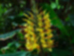
It is reminiscent of Kalopa State Park, another preserve near Honokaa on the lower slopes of Mauna Kea. Wild ginger is everywhere, though not much of it was flowering during this visit. There were a few impressive blossoms though:
This trail has a wonderful primitive jungle feel. Rocks and roots cover the trail and are just as slippery as the mud that surrounds them.


Large sections of the trail are also covered with downed fronds, creating a complicated mosaic beneath your feet:

It's not hard to figure out where the fronds are coming from:
After about 0.7 mile, you arrive at a junction with the Mallway trail. Taking a left turn onto this trail will put you on the shorter loop, providing a pretty smooth descent to the bottom of the preserve. We elected not to turn here, taking instead the Crosstown trail. Surprisingly, the landscape changed immediately at this junction. The Crosstown trail is more of an old road, with rainforest on the left (downhill) and open tree and pasture land on the uphill side. This was the first point in the trek that felt like a “cloud forest”, as the views uphill were of sparse trees fading into dense fog in the distance.

It was quite beautiful and remarkably different from what we had just walked through. Many ohi'a trees lined the road, some exhibiting "air roots", a sign of stress:

After ~1.1 miles we reached the junction with the Pig Skull Trail. While the Crosstown trail continues for a short way to a dead end, we saw no reason to follow it and turned downhill onto Pig Skull. This trail transitioned from more open misty views


to dense rainforest, with limited viewing off the trail to either side. It follows the edge of the preserve and is fence-lined and steeply downhill at times. Once again the views down the trail were the best.


The Pig Skull trail ends at the lower edge of the reserve, and follows an old road called Pipeline on the map. This road has been pretty extensively cleared on either side, and is frankly not very interesting. We ignored the short dead-end legs at either end and made a beeline to the Lower Jurassic trail-head. Of course, for this wide-open unprotected leg of the hike, it was pouring rain. My photography came to a halt at this point.
We were pleased to reach the Jurassic trailhead as it provided a bit of tree canopy shelter, but it is a much tougher uphill walk across wet slippery rocks roots and mud. To our surprise there were several unmarked forks in the trail. We puzzled over these and selected the most-travelled branches, only to discover that all branches reconverge to the main trail. Take whatever forks looks appealing to you!
The entire hike took us about 3 hours and my watch showed that we averaged about 1.9 mph. Pretty slow, but I took a lot of pictures and the rain slowed us down. Overall, we found all the trails to be in very good condition (for rainforest trails), with good signage. The PATH (Public Access Trails Hawaii) volunteer group that takes care of this trail deserves your thanks and support! The reserve reminds me of Kalopa State Park, and both should be on your list of Hawaii Island rainforest hikes.