
Hiking to Green Sand Beach
- Thomas Upton
- May 29, 2023
- 3 min read

Updated: May 9, 2024
A few miles east of the Island's southern-most point (South Point) is a dramatic, partially submerged Pu'u, or cinder cone, whose center is at the shoreline and is the home of one of the world's very few (some say only 4) green sand beaches. It's one of the Big Island's most iconic locations and here's what it looks like in late morning:

The color in this photo looks a bit like moss or algae, but it is actually olivine, a volcanic mineral in the sand that is rare in such quantity. The beach is on the left and access requires clambering down the steep cliffs at far left. It is much easier than it looks. Getting there is not difficult, but it is time consuming. The Hawaii Belt road (Route 11) south from Kailua-Kona runs through numerous small towns and settlements before it turns east at it's southern-most point and turnoff to South Point Road. That road dead ends near the ocean in a well-marked parking lot from which the hike (or ride) to the Green Sand Beach begins. It's about 2.8 miles each way over mostly flat terrain. If you prefer to ride, there are pickup trucks that will take a load of passengers each way over the bumpy 4wd road for a modest fee. Please note however that it is NOT ok to drive your own vehicle to the beach. The paths are already heavily rutted from the truck traffic (see photo below). People planning a day at the beach with all their stuff, typically ride in the pickups. We were up for a walk, and would do so again.
The terrain is mostly pasture land, and seems devoid of the fountain grass that has taken over a lot of areas in the northern part of the island.

The trail is actually a network of 4wd tracks that go from the parking lot to the beach. Ruts have been carved from years of travel over these tracks, ad are so deep the word rut seems inadequate to describe them:

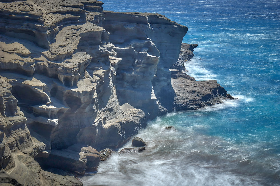
Despite the obvious damage to the land, they are actually pretty interesting to walk in and fairly unique in their depth. It's hard to imagine how they got so deep without swallowing a fair number of vehicles along the way. The trail mostly follows the coast and there are some fabulous ocean scenes. On windy days like the one we experienced, the crashing waves are impressive:

Expect to see lots of swimmers at the beach when you arrive, conveniently edited out of these views. The swells rolling into the beach can be large.
The sandy slope above the beach is very steep and we wondered why no one was "surfing" down it like they do on similar Southern California hillside dunes. We got a chuckle out of these kids who snorkeled it, which we haven't seen before!

We had a picnic lunch and then headed back on the trail. All told a great excursion if you have time! As a parting shot, here's a little memorial we found just off the trail near the parking area:

There's much more to see on BigIslandView.com! See some of the other blog posts for new adventures and explore the extensive photo galleries covering all parts of the Big Island as you plan your visit.


Comments