
Hooray! The Boiling Pots Are Back!

The Wailuku River is the largest river in Hawaii, flowing down from Mauna Kea and draining into Hilo Bay. The riverbed itself lies where old lava flows from Mauna Kea and new flows from Mauna Loa collided thousands of years ago. There are (at least) four major waterfalls and cascades on the river whose drops and features were created by these lava flows. The Boiling Pots are one of these waterfall/cascade areas with the Pe’epe’e falls at the upper end and the Boiling Pots themselves below. Here's how it looked in 2021:


(the river flows out of the top photo at right and into the lower photo at left). Boiling Pots is part of the Wailuku River State Park, which also includes Rainbow Falls further downstream. It is just off Waianuenue Avenue in a residential area several miles up from downtown Hilo (a sign shows where to turn). There are parking areas, public restrooms, and an overlook platform at Boiling Pots. Because the water in this area, particularly in the pots, is quite dangerous to swim in, there is no public access to the river from the park facilities. The pots were created when lava cooled into a series of hexagonal columns running downstream that have since eroded into a series of cascading bowls. When flowing rapidly, the water churns in the bowls washing-machine-style. It's easier to see in this view of one pot during a lesser flow period in 2021:

The churn makes it almost impossible for a swimmer to escape. I visited another formation like this in mainland USA and a number of swimmers have died there. And aside from being a potentially fatal idea, I’ve heard of people being arrested here for violating this restriction.
So, a visit to Boiling Pots is intended mainly to provide a view of the fantastic Jurassic Park-like scene of multiple falls feeding into multiple pots. Since Covid days however, maintenance of this view has progressively declined to the point that the pots were almost impossible to see and vegetation partially blocked views of the falls upstream. While we regularly take visitors to the Wailuku River to observe its amazing waterfalls, we quit going to the Boiling Pots some time ago as it had become pointless. I suspect others did the same. Here's a shot from 2024:

Compare it to a similar shot taken in 2021:

Or to this shot during a flood in 2021:

You can see that in 2024, the river disappears on the right, blocked by foliage down the hillside and by the stream. I did not show a comparison photo of the pots from 2024 vs 2021, because in 2024 you could hardly see them anymore.
Recently, we’ve noted that view management at Hawaii Island State Parks has taken a welcome turn for the better, particularly at Akaka Falls and Rainbow Falls. We wondered if the same might now be true at Boiling Pots. We happened to be in the Hilo area recently, aware that flow in the Wailuku River had reached unprecedented levels during the recent passing of Hurricane Lala. Out of curiosity, we stopped at Boiling Pots. What a revelation!
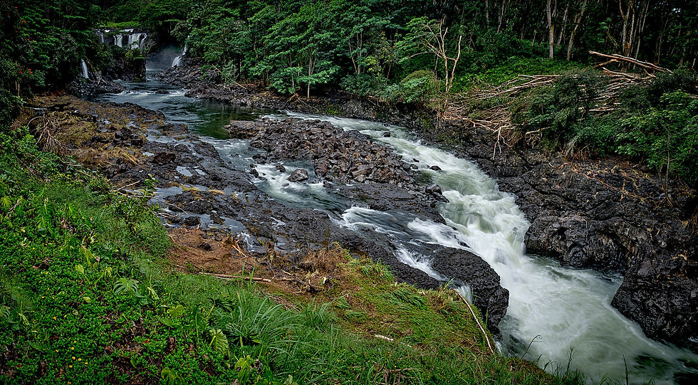
The park clearly received some much-needed pruning and views were significantly improved. In addition, the recent intense flow had removed any remaining vegetation near the river (and added some massive, downed trees on the far banks), opening up the view even more. While the scene is now a bit overly denuded, it reveals the full primordial landscape that the Park protects:
The water flow during our recent visit was somewhat elevated vs normal, but not wildly so. Comparing the current view of the falls

to one taken in the 2021 flooding flow shows all the same falls among the group that makes up Pe’epe’e (which means "Hidden") falls

So the violent flow that came with Lala did not really change much geologically about the Boiling Pots area. But it does seem like it is now possible to see much further downstream than in the past, with a clear view of all the pots until they recede into the next canyon area below:


My best previous view of this scene was the 2021 shot seen near the top of this post and it looks pretty similar. I've repeated here for easy comparison:
The biggest difference is that streamside foliage around the pots is now gone, making it more obvious that the pots exist in a narrow canyon. The foliage will probably return pretty quickly. I can't say for certain that there was never a time between 2021 and 2026 where the view was unobstructed, only that we saw it steadily decline over these years. But, there is no question that this is a huge improvement.
Of course, it would be even nicer if there was an established paved trail leading down to the cascade area providing a better view of the falls, much as the other State Park areas have, but that may never happen. Despite this (in my opinion), Boiling Pots (at the moment) has moved from worst to first on the Wailuku River in terms of the incredible views available. The combination of multiple waterfalls and cascading pots is unique in Hawaii and perhaps the world. I hope that it remains well-tended, especially given the sizable parking and entrance fees that the state now collects from tourists for these parks. My advice is to go soon, while the going is good!


Comments